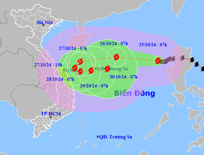
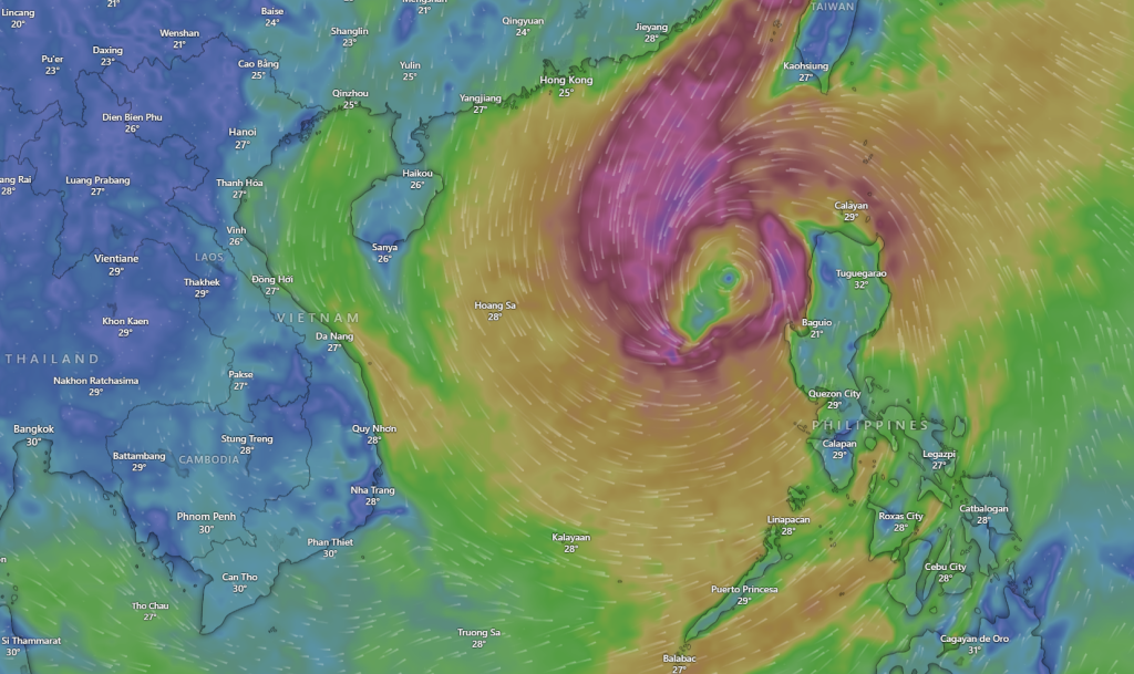
This morning, Typhoon Trami intensified to level 10, with maximum wind speeds reaching 102 km/h, after spending more than half a day over the East Sea. It is expected to change direction and has yet to approach the central coast of Vietnam.
According to the National Center for Hydrometeorological Forecasting, at 7 a.m., Typhoon Trami was located over the northeastern waters of the East Sea, moving westward at a speed of 15 km/h. By 7 a.m. tomorrow, the storm’s center is forecasted to be approximately 210 km from the Hoang Sa archipelago, with wind speeds increasing to level 11-12 (up to 133 km/h), and gusts reaching level 15.
Afterward, the storm is expected to shift slightly southward, moving toward the waters of the Central-Central Coast. However, by October 27, due to the influence of a cold front and a newly formed typhoon off the coast of the Philippines, there is a high likelihood that Trami will reverse direction, turning 180 degrees back toward the central East Sea.
As the typhoon intensifies, the eastern waters of the northern East Sea will experience strong winds at level 8-9, while areas near the storm’s center will see winds reaching levels 10-12 (89-133 km/h) with gusts of up to level 15. Waves are expected to rise between 5-7 meters, with waves near the storm’s center reaching 7-9 meters. Ships operating in these hazardous areas, particularly around the Hoang Sa archipelago, are at risk of thunderstorms, whirlwinds, strong winds, and high waves.
The Japan Meteorological Agency predicts that when Typhoon Trami is approximately 100 km from the Central-Central Coast, it will reverse direction and head back out to sea, maintaining wind speeds around 90 km/h. Similarly, the Hong Kong Observatory forecasts that the typhoon will sustain winds of 110 km/h before changing course.
In an official dispatch on the evening of October 24, Prime Minister Phạm Minh Chính instructed coastal provinces from Thanh Hóa to Phú Yên to monitor and update information on the typhoon and heavy rainfall. Authorities are tasked with tracking and notifying ships to leave dangerous areas and proactively deciding on sea bans.
On land, local authorities are reviewing and preparing to evacuate residents from high-risk areas, particularly those prone to deep flooding, landslides, river mouths, and coastal zones. They are also working to control travel, organize traffic detours, and guide residents to limit movement during the storm and subsequent heavy rains to ensure safety.


