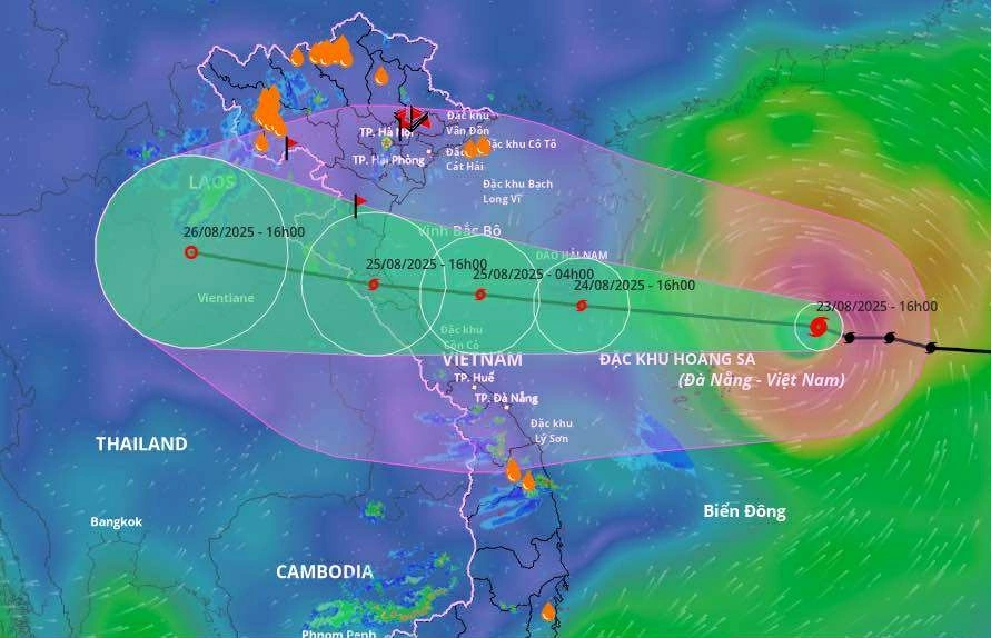
Typhoon Kajiki has strengthened to level 10 and is expected to reach level 13 by tomorrow afternoon, bringing powerful winds and heavy rain across Northern Vietnam, Thanh Hóa, and Huế.
According to the National Center for Hydro-Meteorological Forecasting, as of 4 p.m. today the storm’s eye was about 230 km northeast of the Paracel Islands, with sustained winds of 102 km/h (level 9–10), gusting to level 12. Moving northwest at 25 km/h, Kajiki is forecast to intensify further, reaching level 12–13 as it approaches the coast of Thanh Hóa–Quảng Trị on June 25.
Authorities have issued a level-4 disaster risk warning (on a 5-level scale) for coastal areas from Thanh Hóa to Quảng Trị, citing the combined threats of destructive winds, torrential rainfall, flooding, flash floods, and landslides. The most dangerous zones are Hà Tĩnh and northern Quảng Trị, where evacuation orders may be enforced.
Winds near the storm center are expected to reach level 11–13, with waves as high as 7–9 meters offshore. Storm surges of 0.5–1.2 meters could inundate low-lying coastal and river mouth areas. Rainfall of 200–400 mm is forecast for Thanh Hóa–northern Quảng Trị, with some areas receiving over 700 mm.
Residents are strongly advised to secure homes, avoid going out to sea, and prepare for prolonged heavy rain and flooding from August 25–26. Major cities including Hanoi, Đà Nẵng, and Ho Chi Minh City will also experience rain during this period.
Kajiki, formed from a tropical depression near Luzon (Philippines) on August 22, with significant potential impact as it nears Vietnam’s central coast.


