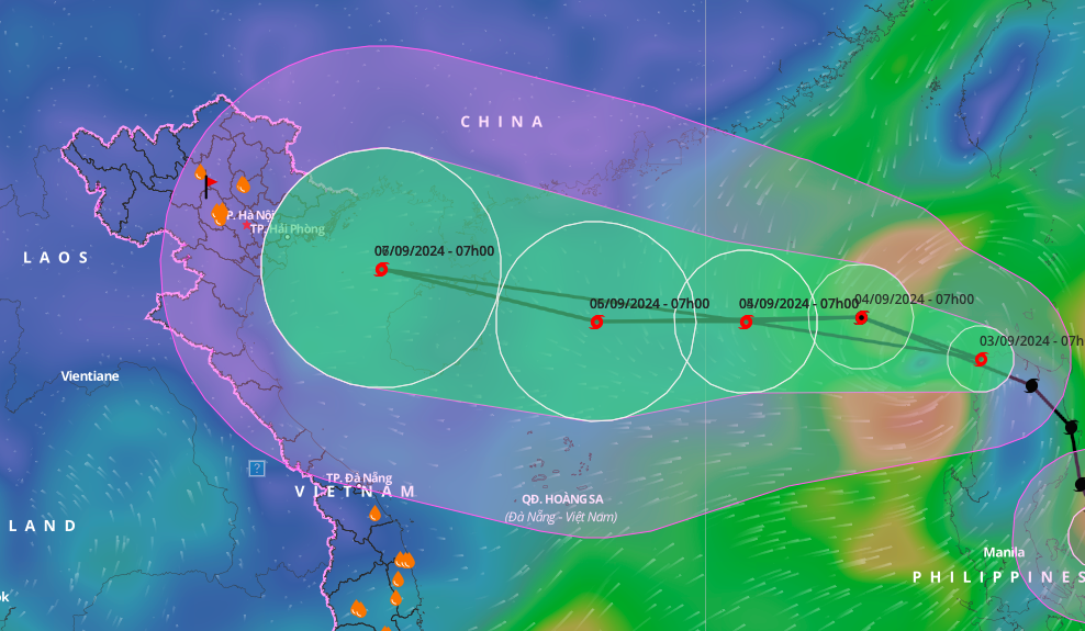
September 3rd, Storm YAGI moved into the northeastern waters of the North East Sea, becoming the third typhoon of the year 2024. As of 10:00 AM, the storm’s center was located at approximately 18.4 degrees North latitude and 119.3 degrees East longitude, in the eastern region of the North East Sea.
The maximum wind speed near the center of the storm is currently classified at level 9, ranging from 75 to 88 km/h, with gusts reaching up to level 11. The storm is advancing in a west-northwest direction at a speed of about 20 km/h.
The Japan Meteorological Agency reports that the strongest winds of tropical storm YAGI are presently around 90 km/h. As the storm progresses towards Hainan Island, wind speeds are anticipated to escalate, potentially exceeding 160 km/h. The Hong Kong Observatory has issued a similar forecast, predicting that the maximum wind speeds could reach up to 155 km/h before the storm crosses over Hainan Island.
According to the National Center for Hydro-Meteorological Forecasting, tropical storm YAGI is expected to intensify rapidly in the northeastern part of the North East Sea from September 4th to 6th. The storm could reach wind speeds of level 12-13, with gusts up to level 16 near its center, and may potentially impact northern and north-central Vietnam.
Given the storm’s unpredictable nature, passengers are strongly advised to stay updated with the latest weather forecasts and regularly check with airlines for any flight changes or cancellations.


