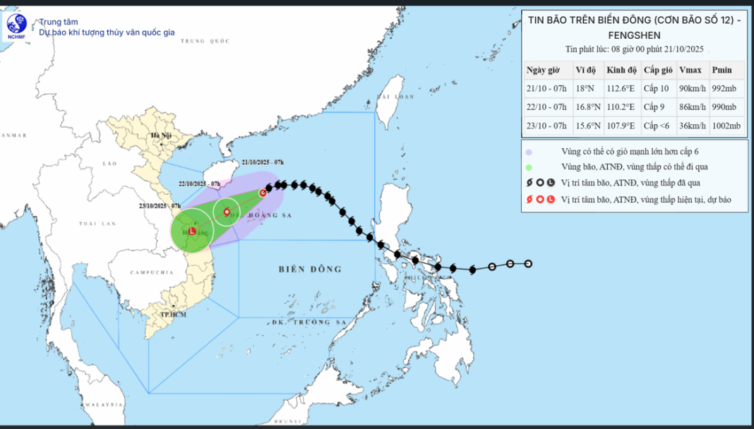
Da Nang is currently on high alert as Tropical Storm Fengshen (Typhoon No. 12) is forecasted to make landfall over the coastal region between Da Nang and Quang Ngai by the evening of October 22, before weakening into a tropical depression. Authorities are urging residents to remain vigilant, as intense rainfall not wind will be the primary concern during this storm.
Weather Overview
Since last night, Da Nang has experienced northeasterly winds at levels 4–5, with scattered light rain. However, meteorologists predict that from October 22, rainfall will increase significantly due to the combined effects of Tropical Storm Fengshen, a cold air mass, and upper-level easterly disturbances.
This convergence of weather systems is expected to produce an intense downpour described as a “water bomb” affecting the central provinces from Hue to Da Nang and Quang Ngai.
Storm Details
As of the latest report, Fengshen is sustaining winds of level 10, with gusts reaching level 12, and continues to move southwestward toward the Da Nang–Quang Ngai coast.
Forecasts indicate that the storm will make landfall between 5:00 p.m. on October 22 and early morning on October 23, gradually weakening into a tropical depression before or shortly after reaching the shore.
The area most affected by strong winds—levels 6–7 with gusts up to levels 8–9 will extend from Hai Van Pass down to Nui Thanh.
Residents can expect the strongest winds late at night on October 22.
Rainfall and Flood Risks
Heavy rain is expected to intensify from the morning of October 22, with the heaviest downpours occurring from noon on October 22 through October 23, potentially lasting until the morning of October 24.
Total rainfall is estimated between 500–600mm, with some areas possibly reaching 700mm. Authorities are warning of localized extreme rainfall, similar to the flooding event of October 2022.
Due to the high volume of rain, urban flooding is highly likely particularly in low-lying and flood-prone areas—starting early on October 23. Some areas could experience flood depths exceeding 1 meter.
Safety Recommendations
Residents are advised to prepare emergency supplies, including food, drinking water, and essential goods for several days. It is also important to have backup power sources, life vests, and flotation devices on hand in case of severe flooding or isolation.
Local authorities urge everyone to stay updated through official weather channels and to avoid unnecessary travel during heavy rain and strong winds. This weather pattern bears strong resemblance to the severe rainfall event on October 14, 2022, and thus should not be underestimated.


