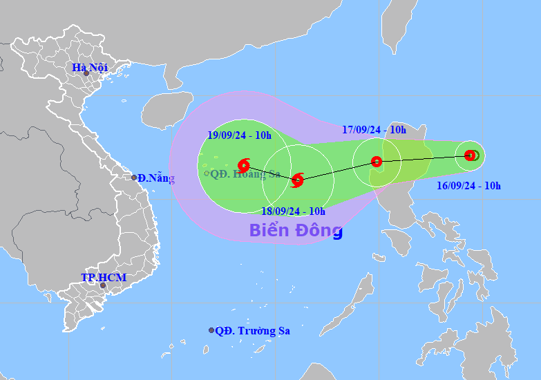
A tropical depression that has formed off the coast of the Philippines is expected to enter the East Sea, heading towards the Hoang Sa (Paracel) Islands tonight and tomorrow. It is forecasted to potentially strengthen into a storm with very complex developments.
10:00 AM today (September 16), the center of the tropical depression was located at approximately 17.1 degrees North latitude and 124.4 degrees East longitude. The maximum sustained winds near the center of the tropical depression were at levels 6-7 (39-61 km/h), with gusts reaching level 9.
According to the National Center for Hydro-Meteorological Forecasting, the tropical depression is moving very quickly, traveling at a speed of 15-20 km/h. It is expected to enter the East Sea tonight and tomorrow morning. By 10:00 AM tomorrow (September 17), the center of the tropical depression will be over the East Sea, maintaining wind speeds of level 7, with gusts up to level 9.
In the following 24 hours (from 10:00 AM on September 17), the tropical depression is predicted to move west-southwest at a speed of about 20 km/h and will continue to intensify into a storm. By 10:00 AM on September 18, the storm center will be in the area of the Hoang Sa (Paracel) Islands, with maximum wind speeds near the center reaching level 8, with gusts of level 10.
In the next 24-48 hours, the storm may change direction, moving west-northwest at a speed of 10-15 km/h.
Due to the influence of the tropical depression, from the morning of September 17, the eastern waters of the northern East Sea will experience heavy showers and thunderstorms, with strong winds at level 7 (50-61 km/h) and gusts at level 9 (75-88 km/h). The sea will be rough, with waves reaching heights of 2-4 meters.
Experts have noted that this storm will have very complex developments in terms of both its path and intensity due to the influence of multiple factors. It is important to continuously follow the latest updates from the National Center for Hydro-Meteorological Forecasting.


